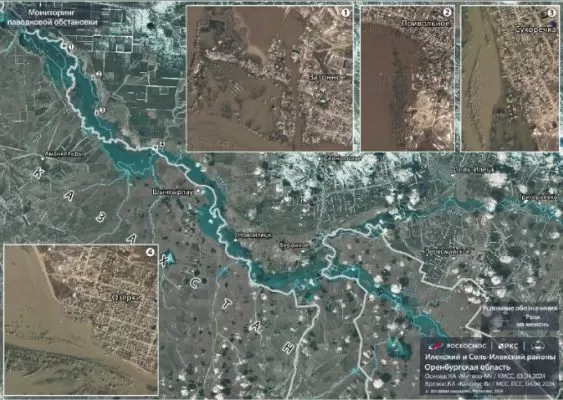
Satellites “Kanopus-V” and “Meteor-M” monitor hydrological conditions in the Orenburg region and other regions of the country prone to floods and floods. This was reported by “Roscosmos”.
Russia, with its vast territory and diverse climate, is constantly facing various natural disasters. One of the most dangerous and destructive among them are floods and floods. These phenomena can cause significant damage to infrastructure, disrupt the lives of people and even lead to casualties. In order to prevent and minimize the consequences of such disasters, it is important to have accurate and timely information about the hydrological situation in the affected areas. This is where the satellites “Kanopus-V” and “Meteor-M” come into play.
Developed by the Russian space agency “Roscosmos”, these satellites are equipped with modern remote sensing devices that allow them to monitor various natural phenomena, including water resources. The “Kanopus-V” satellite, launched in 2012, is specifically designed for monitoring emergencies and natural disasters. Its high-resolution cameras provide detailed images of the Earth’s surface, allowing experts to assess the extent of damage caused by floods and floods. The “Meteor-M” satellite, launched in 2014, also plays an important role in monitoring hydrological conditions. It is equipped with a multi-channel scanner that can detect changes in the Earth’s surface caused by water bodies.
The data collected by these satellites is transmitted to the Russian Emergencies Ministry, which uses it to assess the situation and take necessary measures to prevent and mitigate the consequences of natural disasters. In addition, the information is also shared with other government agencies, such as the Federal Service for Hydrometeorology and Environmental Monitoring, which uses it to create flood and flood forecasts.
The Orenburg region, located in the southern part of Russia, is known for its unpredictable and severe floods. In the past, these floods have caused significant damage to the region’s infrastructure and economy. Therefore, the monitoring of hydrological conditions in this region is of particular importance. The satellites “Kanopus-V” and “Meteor-M” provide valuable information about the water levels in the region’s rivers and reservoirs, as well as the condition of dams and other water infrastructure. This allows authorities to take necessary measures in a timely manner, such as evacuating residents or strengthening dams, to prevent or mitigate the consequences of floods.
But the benefits of these satellites are not limited to the Orenburg region. They also play an important role in monitoring hydrological conditions in other regions of Russia, such as the Volga, Don and Amur regions, which are also prone to floods and floods. The data collected by these satellites is used to create a comprehensive picture of the hydrological situation in the country, which helps in making informed decisions and taking timely actions.
The use of satellites for monitoring hydrological conditions has proven to be very effective and efficient. Unlike traditional methods, such as ground-based observations or aerial surveys, satellites provide a continuous and comprehensive view of the affected areas. They can also cover large territories, which is especially important in a country as vast as Russia. In addition, satellite data is easily accessible and can be quickly analyzed, which allows for faster response to emergencies.
In conclusion, the satellites “Kanopus-V” and “Meteor-M” are playing a crucial role in monitoring hydrological conditions in the Orenburg region and other regions of Russia prone to floods and floods. Their advanced technology and continuous monitoring provide valuable data that helps authorities to take necessary measures to prevent and mitigate the consequences of natural disasters. The use of satellites in this field is a great example of how space technology can be used for the benefit of humanity.

